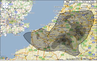
 From Strange Maps:
The oil spill is the worst environmental disaster in US history. But it’s a catastrophe of the creeping, cumulative kind, composed of images familiar from earlier ecocides. How to get a grip on its width and breadth? Obviously: a map. Ingeniously: a map of the area affected by the oil spill transposed on your geographic location of choice – your home, for optimum shock effect.

For anyone who would like to see it without going to the site and typing in a new city, here is the map for if the oil spill were centered over Cambridge: http://www.ifitwasmyhome.com/#loc=Cambridge%2C%20MA%2C%20USA&lat=42.3726399&lng=-71.1096528&x=-71.1096528&y=42.3726399&z=7
Alternatively, the site offers a “Put it in XXX” button on the right, where XXX is is based on the location of your internet address; usually Somerville, Medford or Boston for Cantabridigans. Also note that it seems to anchor the spill at the drilling platform rather than its center of mass, so the bulk of the overlay tends to be above and right of the location chosen due to the prevailing currents. An anchor point of Eastford, CT nearly covers all of Southern New England.